Bhubaneswar: The extremely severe cyclonic storm Mocha, which hit Bangladesh-Myanmar coasts on Sunday afternoon, has triggered severe heatwave in Odisha with the India Meteorological Department (IMD) predicting sultry and hot conditions for the state in the next 24 hours.
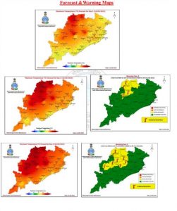
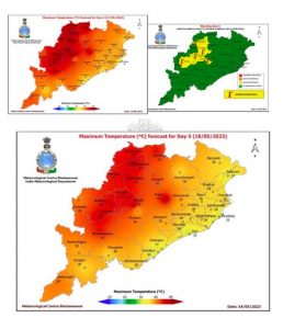
“Westerly/northwesterly winds and high solar insolation, maximum temperature (Day Temperature) is very likely to rise by 3 to 5°C during next 2 days at many places over Odisha. Consequently, heatwave condition is likely in some districts of interior Odisha from May 15 and also maximum temperature (Day Temperature) likely to be more than 40°C and above normal by 3 to 5°C at a few places over the districts of Odisha. People are advised to take precautionary measure while going outside during day time between 11 am and 2 pm,” the MeT office in its midday bulletin.
Yellow warning has been issued for several districts of the state for 3 days.
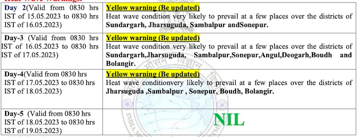
The day temperature may soar to 45°C at 9 places in the state on May 16 with the twin cities of Bhubaneswar and Cuttack recording 40°C, the forecast further said. The heatwave conditions returned as the cyclonic movement dragged along all the moisture with it and with the flow of north-westerly wind towards the state, according to wether experts.
Meanwhile, gale and heavy rain lashed coasts of Bangladesh and Myanmar as Cyclone Mocha made landfall close close to north of Sittwe (Myanmar) as an Extremely Severe Cyclonic Storm with wind speed of 180-190 kmph gusting to 210 kmph between 12.30 pm and 2.30 pm. The system is continuing the weakening trend and will weaken into a very severe cyclonic storm during the next 3 hours, the MeT office added.


