Bhubaneswar: Heatwave conditions are likely to return to Odisha, mostly in western and interior parts, from May 22 with a gradual rise in the mercury level by three to four degrees Celsius at most places from May 21.
According to the India Meteorological Department (IMD), there will be no large change in maximum temperature during the next 3 days and gradually rise by 3-4 degree thereafter at most places in the state. Heatwave conditions are likely to prevail at one or two places in Mayurbhanj, Keonjhar, Sundargarh, Jharsuguda, Bargarh, Sonepur, Boudh and Balangir on May 22.
“Change in prevailing wind pattern will support the rise in the mercury level. Day temperature, at present, stands a little above normal at isolated places in interior parts,” said head of the Meteorological Centre, Bhubaneswar, H R Biswas.
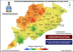
On Wednesday, the mercury hovered between 40 and 42 degrees Celsius at nine places in the state with Boudh recording the highest of 42.5 degrees Celsius followed by Jharsuguda and Deogarh at 41.2 degrees Celsius. Bhubaneswar recorded 36 degrees Celsius. Thunderstorm activities were also reported at isolated places.
Thunderstorm warning has been issued for 15 districts on Thursday. Thunderstorm with lightning and gusty surface wind speed reaching 30-40 kmph are very likely to occur at one or two places in Malkangiri, Koraput, Nabarangpur, Rayagada, Kalahandi, Kandhamal, Nuapada and thunderstorm with lightning is very likely at one or two places in Boudh, Angul, Dhenkanal, Sundargarh, Mayurbhanj, Gajapati, Ganjam and Keonjhar.


