Bhubaneswar: Odisha is likely to experience very heavy rain during the next three days due to the depression over south coastal Odisha and its neighbourhood, India Meteorological Department (IMD)’s regional centre informed on Sunday.
Squally winds speed reaching 40-50 kmph gusting to 60 kmph is also likely over the sea along and off Odisha coast and northwest adjoining westcentral Bay of Bengal till September 12.
According to the MeT office, the depression over south coastal Odisha and neighbourhood moved west northwestwards with a speed of 25 kmph during the past 3 hours and lay centred at 8.30 am over south Odisha about 80 km east-southeast of Bhawanipatna (Odisha), 110 km west-northwest of Gopalpur (Odisha), 210 km east-northeast of Jagdalpur (Chhattisgarh) and 260 km east-southeast of Kanker (Chhattisgarh). “It is likely to move west-northwestwards across south Odisha and south Chhattisgarh during the next 24 hours and weaken gradually,” it added.
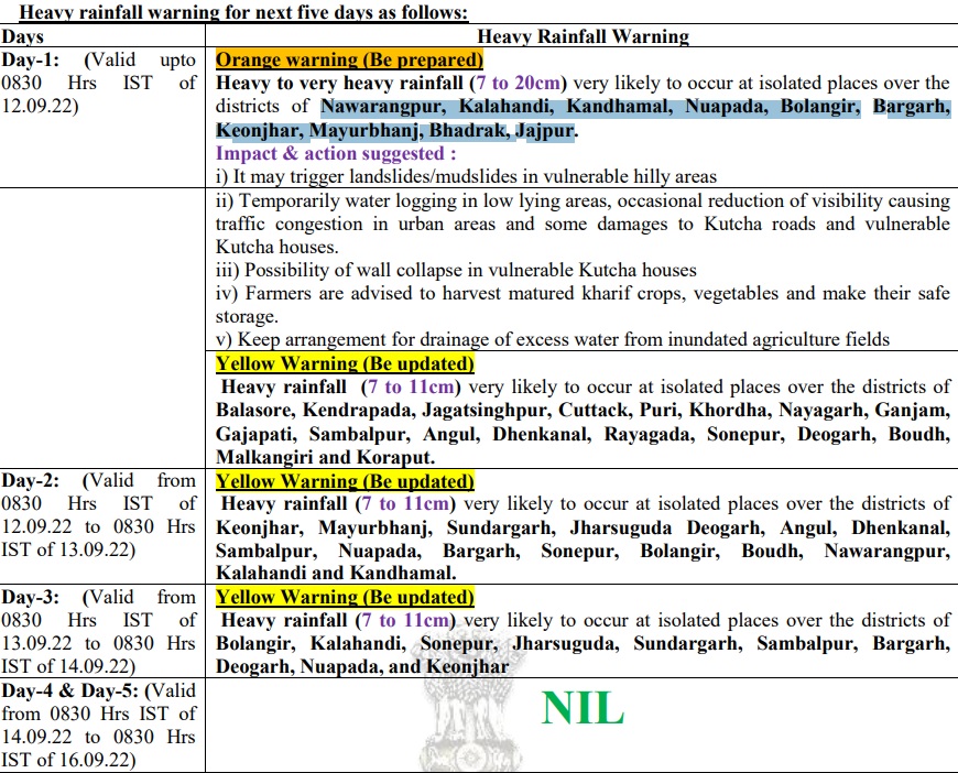
Meanwhile, an orange warning for heavy to very heavy rainfall (7 to 20cm) has been issued for some parts of Nabarangpur, Kalahandi, Kandhamal, Nuapada, Balangir, Bargarh, Keonjhar, Mayurbhanj, Bhadrak and Jajpur districts till 8.30 am of September 12. Heavy rainfall (7 to 11cm) is also likely to occur at isolated places in Balasore, Kendrapada, Jagatsinghpur, Cuttack, Puri, Khurda Nayagarh, Ganjam, Gajapati, Sambalpur, Angul, Dhenkanal, Rayagada, Sonepur, Deogarh, Boudh, Malkangiri and Koraput during this period.
Yellow warning for heavy rainfall continues for the next two days.
While fishermen have been advised not to venture into the sea along and off Odisha coast and northwest adjoining west-central Bay of Bengal till September 12, Local Cautionary Signal Number Three (LC-3) has been hoisted at four ports – Gopalpur, Paradip, Puri, and Dhamra – in the state.


