Bhubaneswar: The cyclonic circulation over Southeast Bay of Bengal and neighbourhood is likely to intensify into a low-pressure area in the next 12 hours, the India Meteorological Department (IMD) said on Wednesday morning.
“The cyclonic circulation now lies over Southeast adjoining Southwest Bay of Bengal extending up to 3.1 km above mean sea level. It is likely to move westwards. Under its influence, a low-pressure area is likely to form over central parts of South Bay of Bengal during next 12 hours,” the 8 am bulletin said.
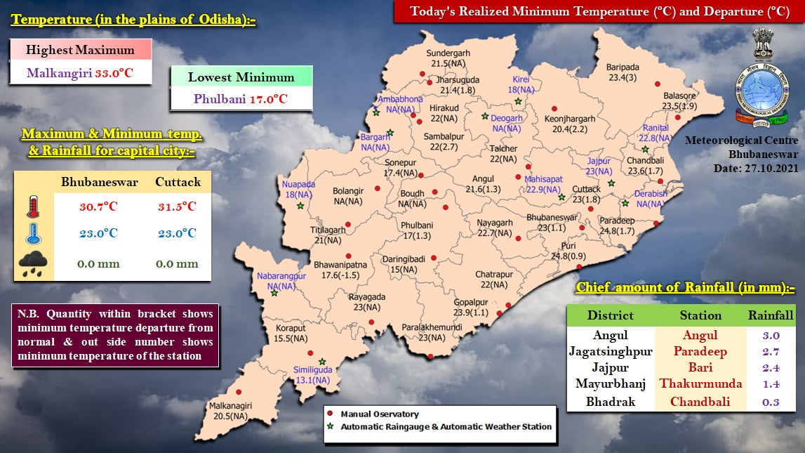
On Tuesday, the Bhubaneswar Meteorological Centre had forecast light to moderate rainfall in some parts of Odisha for three days from October 28.
OCTOBER 28
Gajapati, Ganjam, Puri, Rayagada and Koraput
OCTOBER 29
Gajapati, Ganjam, Rayagada, Koraput, Malkangiri and Nabarangpur
October 30
Malkangiri and Koraput
The weather will remain dry in the remaining districts of the state, it added.
According to Skymetweather, the cyclonic circulation is over South-Central Bay of Bengal and under its influence, a low-pressure area is expected to form on October 27. It will move in a westerly direction towards Tamil Nadu. A trough from this cyclonic circulation is extending up to the southeast Arabian Sea across Tamil Nadu and Kerala, it added.
Also Read: Fresh Low Pressure Over Bay Of Bengal Later Next Week, Cyclone Unlikely
Notably, heavy rain had pounded Odisha after as a low-pressure area formed over Gangetic West Bengal on October 18.
The state had also experienced rain on October 16-17 when a low-pressure area was formed over the east-central Bay of Bengal and its neighbourhood under the influence of a cyclonic circulation on October 14.
Meanwhile, Similiguda was the coldest at 13.1 degree celsius in the last 24 hours. Six other places recorded below 20 degree Celcius.


