Bhubaneswar: A low-pressure area is likely to form over Southeast Bay of Bengal around April 7, the India Meteorological Department (IMD) said, adding that Andaman & Nicobar Islands are likely to experience isolated heavy rainfall on April 5-6.
Squally weather conditions will prevail on these days with wind speed reaching 40-50 kmph gusting to 60 kmph over Southeast Bay of Bengal and the south Andaman Sea. On April 7, the wind speed reaching 45-55 kmph gusting to 65 kmph would blow over central parts of south Bay of Bengal. Fishermen are advised not to venture into this area, the MeT office added.
“An upper air cyclonic circulation is likely to form over south Andaman Sea and neighbourhood on April 6. Under its influence, a low-pressure area is likely to form over the south-east Bay of Bengal in the subsequent 24 hours,” scientist, Bhubaneswar Meteorological Centre, Umasankar Das told the media.
The system’s path can be predicted only after it is formed, he added.
Senior meteorologist Jason Nicholla tweeted the latest GPP from IMD, which showed a high chance for the development of a potential cyclogenesis zone in the Andaman & Nicobar Islands later this week.
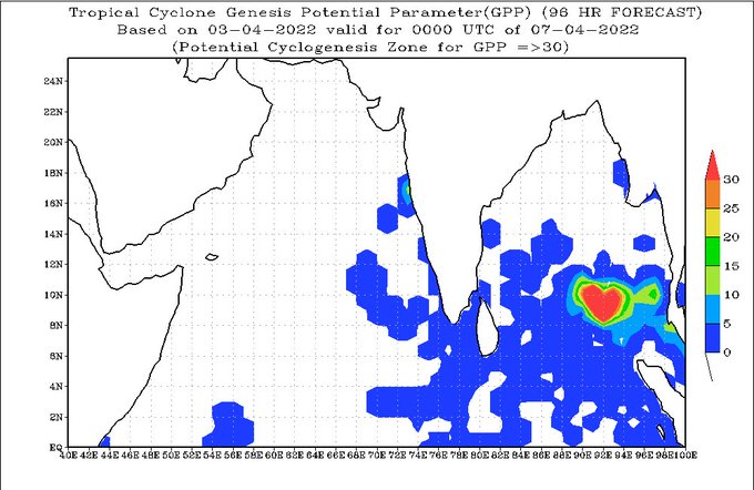
“An area of low pressure is expected to form in the vicinity of the Andaman & Nicobar Islands around midweek. Some strengthening is possible late next week. Track uncertain, but areas from eastern India to Bangladesh should monitor,” he added.
According to Skymet Weather services, this weather system may intensify into a depression, further into a deep depression and move towards the east coast of India. “Such systems developing in the month of April normally take north-westerly route initially and recurve in the northeast direction,” it added.
Notably, the Bay of Bengal has seen two storms, Fani and Marutha, in the month of April since 2010. These brewed towards the third week of April and even later. A depression over the central Bay of Bengal strengthened into a cyclonic storm on April 27, 2019, and made landfall near Puri on May 3 as an extremely severe cyclonic storm, triggering heavy rainfall coupled with high-velocity winds with a speed of 175 kmph in vast areas.
In 2017, the other tropical storm ‘Marutha’ developed over the Andaman Sea and crossed the Myanmar coast near Sandoway early on April 17. It lasted for merely 24 hours.
Meanwhile, Odisha is likely to witness light to moderate rain/ thundershower at one or two places in Malkangiri, Koraput, Rayagada, Gajapati, Ganjam, Kandhamal, Mayurbhanj, Balasore and Bhadrak in the next 24 hours. Similar weather is likely to prevail at one or two places in Malkangiri, Koraput, Rayagada, Gajapati and Mayurbhanj in the subsequent 24 hours.
The rainfall activity has been attributed to moisture availability and local heating. There will, however, be no large change in maximum temperature in Odisha in the next four days.


