Bhubaneswar: Heavy to very heavy rain is likely to pound many parts of Odisha for a week as a low pressure area has formed in the region, the India Meteorological Department (IMD) said on Sunday.
The southwest monsoon, which is active in the state, is likely to gain more steam with the formation of the low pressure area over the Gangetic West Bengal and neighbourhood.
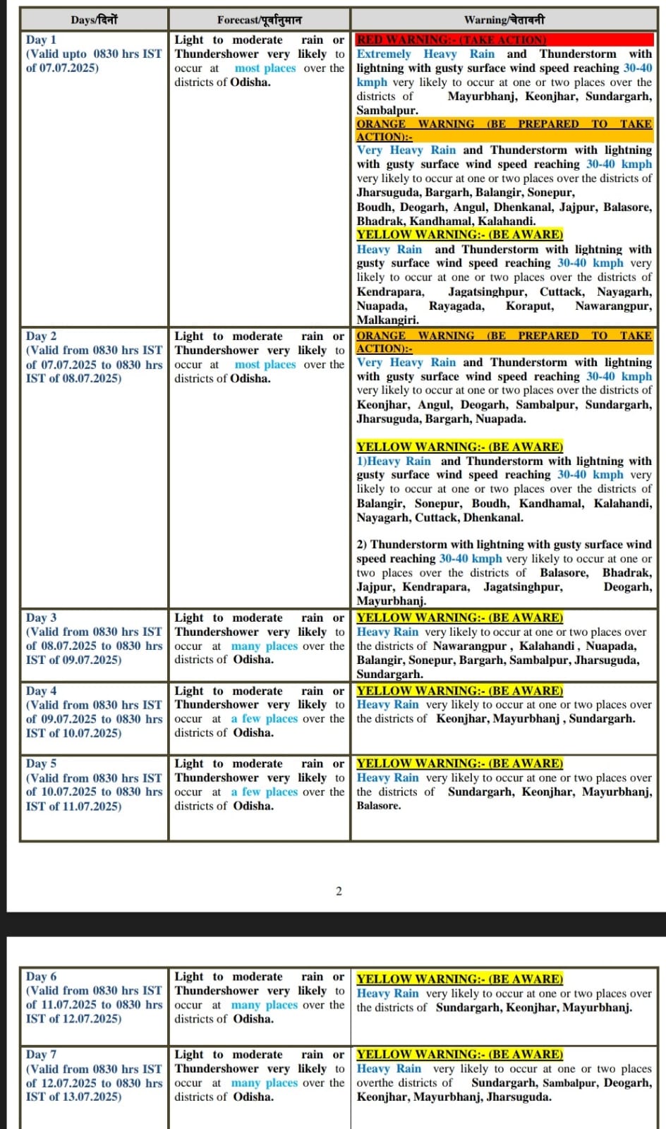
While extremely heavy rain is likely to batter several areas in next 24 hours, downpour of varied intensity may lash the state up to the morning of July 13. The weather agency has issued red, orange and yellow warnings for different areas during the period.
Similarly, squally weather is likely to prevail with wind speed 35-45 kmph gusting to 55 kmph along and off Odisha coasts on July 6 and 7. As sea condition is likely to be rough to very rough, fishermen are advised not to venture into the sea, along and off Odisha coast on these days.
The weather agency has issued a red warning for Mayurbhanj, Keonjhar, Sundargarh and Sambalpur districts for the next 24 hours. Extremely heavy rain and thunderstorm with lightning with gusty surface wind speed reaching 30-40 kmph is likely to occur at one or two places over these districts during the period.
Orange Warning: Heavy to very heavy rain and thunderstorm with lightning, gusty surface wind speed reaching 30-40 kmph may occur at one or two places over the districts of Jharsuguda, Bargarh, Balangir, Sonepur, Boudh, Deogarh, Angul, Dhenkanal, Jajpur, Balasore, Bhadrak, Kandhamal, and Kalahandi.
Yellow Warning: Heavy rain and thunderstorm with lightning with gusty surface wind speed reaching 30-40 kmph very likely to occur at one or two places over the districts of Kendrapada, Jagatsinghpur, Cuttack, Nayagarh, Nuapada, Rayagada, Koraput, Nabarangpur, and Malkangiri.
On July 7-8, orange warning of heavy to very heavy rain and thunderstorm, lightning and gusty surface wind speed reaching 30-40 kmph was issued for some places of Keonjhar, Angul, Deogarh, Sambalpur, Sundargarh, Jharsuguda, Bargarh, and Nuapada districts.
Yellow Warning: Heavy rain and thunderstorm with lightning, and gusty surface wind speed reaching 30-40 kmph may occur at one or two places over the districts of Balangir, Sonepur, Boudh, Kandhamal, Kalahandi, Nayagarh, Cuttack, and Dhenkanal.
Thunderstorm with lightning, and gusty surface wind speed reaching 30-40 kmph may occur at one or two places over the districts of Balasore, Bhadrak, Jajpur, Kendrapada, Jagatsinghpur, Deogarh, and Mayurbhanj.
On July 8-9, yellow warning of heavy Rain very likely was issued for some places over the districts of Nabarangpur , Kalahandi , Nuapada, Balangir, Sonepur, Bargarh, Sambalpur, Jharsuguda, and Sundargarh.
Weather Forecast & Warnings:


