Bhubaneswar: A cyclonic circulation over coastal Odisha and neighbourhood is likely to trigger thunderstorm in several parts of the state.
The Regional Centre of India Meteorological Department here has forecast thunderstorm with lightning at one or two places over the districts of Gajapati, Rayagada, Kandhamal, Malkangiri and Koraput till 8.30 am of Monday (May 23).
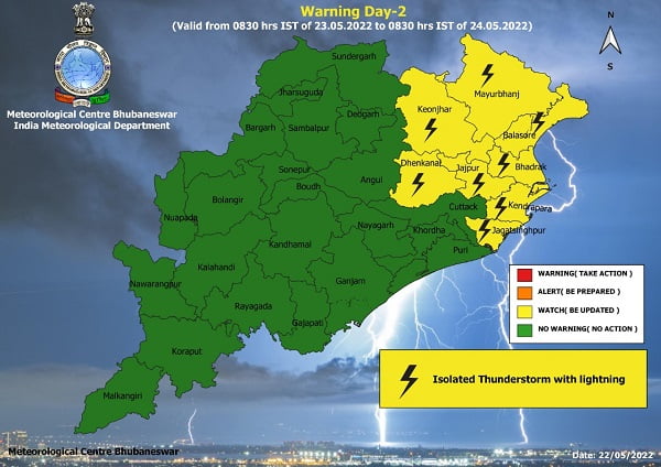
Similarly, a yellow warning of thunderstorm with lightning has ben issued for Mayurbhanj, Balasore, Bhadrak, Jajpur, Jagatsinghpur, Kendrapada , Dhenkanal and Keonjhar districts from 8.30 am of May 23 to 8.30 am of May 24.
For the next 24 hours, till 8.30 am of May 25, the IMD has issued a warning of thunderstorm with lightning and gusty surface wind speed reaching 40-50 kmph for the districts of Jharsuguda, Sundargarh, Deogarh, Keonjhar, Mayurbhanj, Balasore, Bhadrak, Angul, Dhenkanal, Sambalpur, Cuttack, Khurda, Jagatsinghpur, Kendrapada, Jajpur and Puri.
However, these showers are unlikely to bring any large change in maximum temperature (day temperature) over the districts of interior Odisha during the next 4-5 days.
Maximum temperature is very likely to fall by 3-4 degree Celsius at most places over the districts of coastal Odisha during the next 24 hours and it will rise gradually by 2-4 degree Celsius during the subsequent 3-4 days.


