Bhubaneswar: The very severe cyclonic storm Yaas crossed North Odisha coast about 20 km south of Balasore between 10.30 am and 11.30 am on Wednesday with an estimated wind speed of 130-140 kmph gusting to 155 kmph, the India Meteorological Department (IMD) said.
It is likely to move north-northwestwards and weaken gradually into a severe cyclonic storm during the next 3 hours and into a cyclonic storm during the subsequent 6 hours.
May 26:
1.30 PM: The very severe cyclonic storm ‘Yaas’ weakened into a severe cyclonic storm and lay centred at 12.30 hrs over north coastal Odisha, about 15 km west-southwest of Balasore. The current intensity is 110-120 kmph gusting to 130 kmph.
It is likely to move north-northwestwards and weaken gradually into a cyclonic storm during the next 6 hours.
12.30 PM: The system moved northwestwards and lay centred at 11.30 hrs over north coastal Odisha, about 15 km south-southwest of Balasore.
Wind speed will decrease gradually becoming 90-100 kmph gusting to 110 kmph during the next 3 hours and 60-70 kmph gusting to 80 kmph during subsequent 6 hours.
Tidal waves of height 1-2 meters above astronomical tide are likely to inundate low-lying areas of Balasore, Bhadrak, districts during the next 3 hours and decrease gradually thereafter.
Light to moderate rainfall at most places with heavy to very heavy rains at a few places with extremely heavy falls at isolated places over north interior Odisha during next 24 hours and heavy to very falls at isolated places over coastal Odisha during next 12 hours.
11 AM: The very severe cyclonic storm lay centred at 10.30 hrs over the northwest Bay of Bengal, about 25 km south of Balasore. It has moved north-northwestwards with a speed of around 14 kmph during the past 6 hours.
The system is now crossing the coast to the south of Balasore. The landfall process will take another 2 hours to complete. It would cross North Odisha-West Bengal coasts to the South of Balasore in 3 hours as a very severe cyclonic storm with wind speed of 130-140 kmph gusting to 155 kmph.
9.30 AM: The very severe cyclonic storm lay centred at 8.30 hrs over the northwest Bay of Bengal, about 45 km north-northeast of Dhamra, 60 km southwest of Digha and 40 km south-southeast of Balasore. It has moved north-northwestwards with a speed of around 17 kmph during the past 6 hours.
The landfall process has commenced and the system is likely to cross North Odisha-West Bengal coasts to the South of Balasore within the next 3 hours as a very severe cyclonic storm with wind speed of 130-140 kmph gusting to 155 kmph.
130-140 kmph gusting to 155 kmph along and off Bhadrak and Balasore districts and 100-110 kmph gusting to 120 kmph along and off Kendrapada at the time of landfall.
8.30 AM: The very severe cyclonic storm lay centred at 7.30 hrs over northwest Bay of Bengal, about 45 km eastnortheast of Dhamra, 70 km south-southwest of Digha and 50 km south-southeast of Balasore.
The landfall process commenced around 9 am and it will continue for 3-4 hours between north of Dhamra and south of Balasore close around Bahanaga block coast, tweeted SRC P K Jena.
Wind Speed at 7.30 am:
80-90 kmph gusting to 100 kmph is prevailing along and off North Odisha coast. Balasore-78, Chandbali-33., Paradip- 39, Bhubaneshwar-30, Puri-15
70-80 kmph gusting to 90 kmph along and off adjoining West Bengal Coast.
8 AM: The very severe cyclonic storm lay centred at 6.30 hrs over Northwest Bay of Bengal, about 40 km east of Dhamra, 80 km south-southwest of Digha and 80 km south-southeast of Balasore. It moved north-northwestwards with a speed of about 15 kmph during the past 6 hours.
Light to moderate rainfall at most places with heavy to very heavy rains at a few places with extremely heavy falls at isolated places in Jagatsinghpur, Kendrapada, Jajpur, Bhadrak, Balasore, Mayurbhanj, Cuttack, Dhenkanal, Keonjhar and heavy falls at isolated places in Puri, Khurda, Angul, Deogarh and Sundargarh.
130-140 kmph gusting to 155 kmph along and off Bhadrak and Balasore districts and 100-110 kmph gusting to 120 kmph along and off Kendrapada district. Windspeed will decrease gradually after landfall becoming 65-75 kmph gusting to 85 kmph by evening.
7 AM: At 5.30 am, Cyclone Yaas was located 40 km east of Dhamra, 90 km south-southwest of Digha and 90 km south-southeast of Balasore.
SRC Pradeep Jena informed that the landfall has been delayed and the process may start around 10-11 am.
May 25:
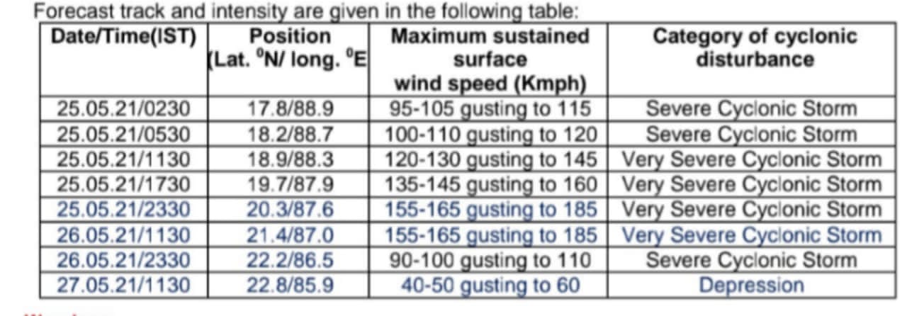
9 PM: Cyclone Yaas over the northwest and Bay of Bengal has intensified into a very severe cyclonic storm. It moved north-northwestwards with a speed of about 15 kmph during the past 6 hours and lay centred at 17.30 hrs, about 160 km east-southeast of Paradip (Odisha), 250 km south-southeast of Balasore (Odisha), 240 km south-southeast of Digha (West Bengal) and 230 km south of Sagar Islands (West Bengal).
6.20 PM: Severe Cyclonic Storm ‘Yaas’ over northwest and adjoining west-central Bay of Bengal moved north-northwestwards with a speed of about 15 kmph during the past 6 hrs & about 200 km southeast of Paradip, 290km south-southeast of Balasore.
6 PM: Squally wind speed reaching 40-50 kmph gusting 60 kmph would prevail in Ganjam, Khurda, Cuttack, Jajpur and Mayurbhanj districts of Odisha and Howrah, Hooghly, north 24Parganas Districts of West Bengal from the evening of May 25. It would further increase becoming gale wind speed 155-165 kmph gusting to 185 kmph over northwest Bay of Bengal and along and off north Odisha and adjoining West Bengal coasts, including Jagatsinghpur, Kendrapada, Bhadrak, from early hours of May 26 and will extend to Balasore district of Odisha from the forenoon, 120-130kmph gusting to 145 kmph would prevail in Mayurbhanj district during the same period. Gale wind speed reaching 80-90 kmph gusting to 100 kmph would prevail over Puri, Cuttack, Khurda, Jajpur and Nayagarh districts of Odisha during the same period. The wind speed reaching 60-80 kmph gusting to 90 kmph would prevail along and off Ganjam and the remaining interior districts of north Odisha.
Tidal waves of height 2-4 meters above astronomical tide are likely to inundate low-lying areas of Medinipur, Balasore, Bhadrak and about 2 metres above astronomical tide are likely to inundate low-lying areas of South 24 Parganas, Kendrapara and Jagatsinghpur districts around the time of landfall.
4 PM: Cyclone Yaas, which was centred about 280 km south-south east of Paradip, is expected to cross the Odisha coast at Soro-Bahanaga in Balasore district on Wednesday morning, according to the Centre of Environment and Climate (CEC) of Siksha ‘O’Anusandhan (SOA) here.
The system is likely to move in a north- north-west direction and cross the coast with wind speed of around 100 km per hour gusting to 120 kmph, CEC Director Dr Sarat Chandra Sahu informed.
Landfall could occur any time between midnight and 4 am on Wednesday, he said.
Light to moderate rain would be experienced in Bhubaneswar with wind speed reaching 40 kmph gusting to 50 kmph by Tuesday evening.
Sahu said the wind speed might vary between 70 km and 100 km per hour in the coastal belt stretching from Jagatsinghpur to Balasore district from Tuesday afternoon.
Heavy to very heavy rainfall could occur at many places with extremely heavy fall likely at few places in the districts of Kendrapara, Bhadrak, Balasore, Mayurbhanj, Jajpur, Keonjhar, Sundargarh, Deogarh, Jharsuguda, Sambalpur, Dhenkanal and Angul from tonight, he said.
The districts of Balasore, Mayurbhanj, Keonjhar, Sundargarh, Jajpur and Dhenkanal could experience more than 250 mm of precipitation, he added.
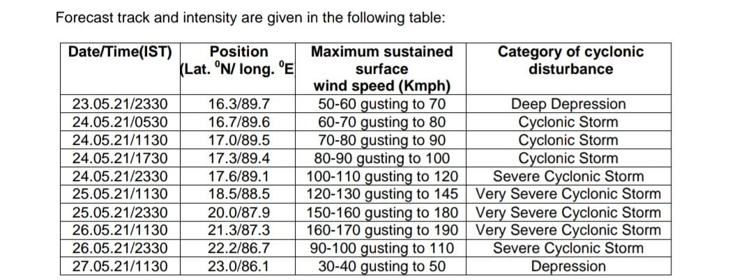
1 pm: Yaas is located around 280 km south-southeast of Paradip (Odisha) and 380 km south-southeast of Balasore. It is moving at about 17 kmph. It is expected to move north-northwestwards, and reach the coast very close to Chandbali-Dhamra port by the early morning of Wednesday. It is very likely to cross north Odisha-West Bengal coasts between Paradip and Sagar Island close to north of Dhamra and south of Balasore, during noon of Wednesday, as a very severe cyclonic storm.
9.30 am: The severe cyclonic storm over the east-central Bay of Bengal moved northwestwards with a speed of about 10 kmph during the past 6 hours, and lay centred at 5.30 am, about 320 km south-southeast of Paradip (Odisha), 430 km south-southeast of Balasore (Odisha), 420 km south-southeast of Digha (West Bengal) and 470 km south-southwest of Khepupara (Bangladesh).
Light to moderate rainfall at many places with heavy to very heavy rainfall in Puri, Jagatsinghpur, Khurda, Cuttack, Kendrapada, Jajpur, Bhadrak, Balasore districts and heavy rain in Ganjam, Dhenkanal, Mayurbhanj districts on May 25, heavy to very heavy rains at a few places with extremely heavy falls at isolated places in Jagatsinghpur, Cuttack, Kendrapada, Jajpur, Bhadrak, Balasore, Mayurbhanj, Dhenkanal, Keonjhar and heavy falls at isolated places in Puri, Khurda, Angul, Deogarh, Sundergarh on May 26 and heavy to very heavy with extremely heavy falls at isolated places in north interior Odisha on May 27.
7.30 am: The severe cyclonic storm over the east-central Bay of Bengal moved north-northwestwards with a speed of about 9 kmph during the past 6 hours, and lay centred at 2.30 am, about 360 km south-southeast of Paradip (Odisha), 460 km south-southeast of Balasore (Odisha), 450 km south-southeast of Digha (West Bengal) and 480 km south-southwest of Khepupara (Bangladesh).
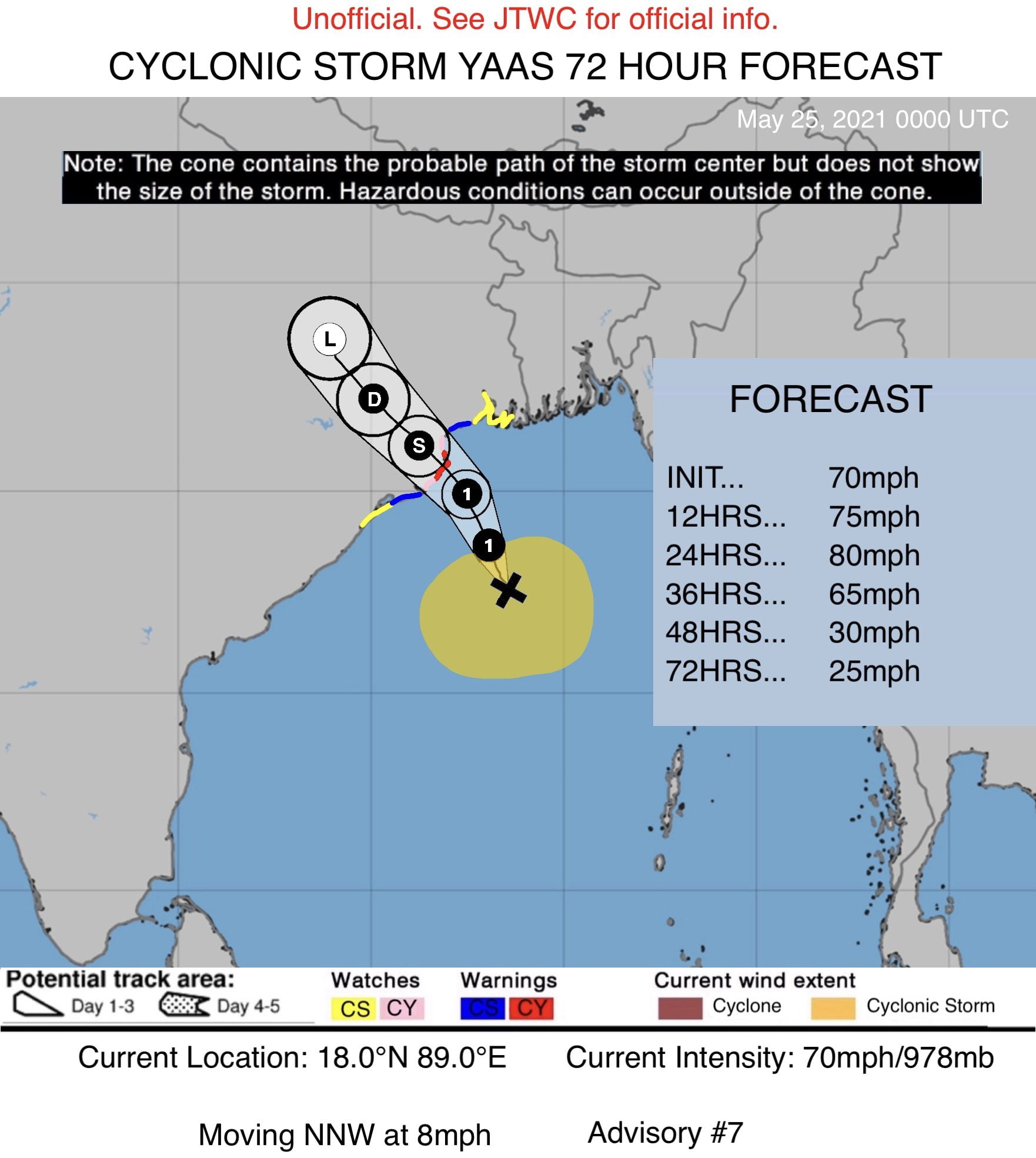
6 am: The Indo-Pacific Tropical Cyclone Warning Centre said that Yaas was gradually strengthening. Maximum wind speed has increased to 70mph. It is expected to intensify slightly more before landfall in Odisha in 30 hours as a dangerous cyclone capable of producing widespread storm surge impacts, and inland flooding.
2 am: The cyclonic storm over the east-central Bay of Bengal moved north-northwestwards with a speed of about 10 kmph during past 6 hours, intensified into a severe cyclonic storm and lay centred at 23.30 on Monday, about 390 km south-southeast of Paradip (Odisha), 490 km south-southeast of Balasore (Odisha), 470 km south-southeast of Digha (West Bengal) and 500 km south-southwest of Khepupara (Bangladesh).
May 24:
10 pm: Cyclone Yaas lay centered 450 km south-southeast of Paradip and 540 km south-southeast of Digha (WB). It is moving north-northwestward, and will cross between Paradip and Sagar Island around Balasore, during noon of 26th May as a very severe cyclonic storm.
YAAS over Eastcentral BoB, lay centred at 1730 hrs IST of 24th May about 450 km south-southeast of Paradip (Odisha) and 540 km south-southeast of Digha (WB), move north-northwestward, to cross between Paradip and Sagar Island around Balasore, during noon of 26th May as a VSCS. pic.twitter.com/wPYGm6Quqr
— India Meteorological Department (@Indiametdept) May 24, 2021
11.30 am: The cyclonic storm over the east-central Bay of Bengal moved north-northwestwards with a speed of about 4 kmph during the past 6 hours, and lay centred about 630 km north-northwest of Port Blair (Andaman Islands), 520 km south-southeast of Paradip (Odisha), 620 km south-southeast of Balasore (Odisha) and 610 km south-southeast of Digha (West Bengal).
8.30 am: The Cyclonic Storm Yaas lay, which lay over East-central Bay of Bengal, has moved north-westwards with a speed of 2 kmph during the past 6 hours.
As of 8.30 am on Monday, it lay centred over East-central Bay of Bengal about 620 km north-northwest of Port Blair (Andaman Islands), 530 km south-southeast of Paradip (Odisha), 630 km south-southeast of Balasore (Odisha) and 620 km south-southeast of Digha (West Bengal), the IMD informed on Monday noon.
5.30 am: The deep depression over east-central Bay of Bengal, which remained practically stationary during the past six hours, intensified into cyclonic storm ‘Yaas’ and lay centred over east-central Bay of Bengal, about 600 km north-northwest of Port Blair (Andaman Islands), 540 km south-southeast of Paradip (Odisha), 650 km south-southeast of Balasore (Odisha) and 630 km south-southeast of Digha (West Bengal).
3.48 am: Vigorous organised clouds associated with the deep depression over east-central BayofBengal.
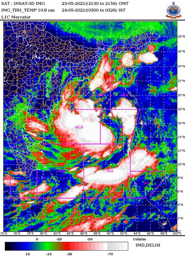
3.30 am: The depression over east-central Bay of Bengal intensified into a deep depression and is about 540 km south-south-east of Paradeep and about 650 km south-southeast of Balasore. It is very likely to intensify into a cyclonic storm by May 24 morning and further into a very severe cyclonic storm during the subsequent 24 hours. It would continue to move north-northwestwards, intensify further and reach northwest Bay of Bengal near north Odisha and West Bengal coasts by May 26 morning. It is very likely to cross north Odisha – West Bengal coasts between Paradip and Sagar islands by May 26 evening as a very severe cyclonic storm.
May 23:
8:30 pm: The cyclone lay centred around 590 km north-northwest of Port Blair at 5. 30 pm according to IMD.
Depression over eastcentral Bay of Bengallay lay centred at 1730 hrs IST of today, the 23rd May, 2021 about 590 km north-northwest of Port Blair. To intensify into a Cyclonic Storm by 24th May morning and further into a Very Severe Cyclonic Storm during the subsequent 24 hrs. pic.twitter.com/LecHxMwDC7
— India Meteorological Department (@Indiametdept) May 23, 2021
7 pm: Centre decided to send 10 additional NDRF teams to Odisha. NDRF Director General Satya Narayan Pradhan said in New Delhi on Sunday that the Centre had earlier sent 22 teams to Odisha. But following the request of Special Relief Commissioner (SRC), 10 more teams will be airlifted to the state by this evening.
The Indian Navy, Indian Army and Coast Guard along with ships and aircrafts have also been deployed. INS Dega at Visakhapatnam and INS Rajali near Chennai are expected to undertake aerial survey of the most affected areas as required.

3 pm: State Energy Minister Dibya Shankar Mishra said standby arrangements have been made in case of power outage. Discoms such as Tata have been directed to restore any power failure on war footing basis. All COVID hospitals have been provided with emergency power backup.
1 pm: Prime Minister Narendra reviewed cyclone preparedness.
11.30 am: IMD Director General Mrutyunjay Mohapatra informed that the system lay about 560 km north-northwest of Port Blair (Andaman Islands), 590 km east-southeast of Paradip, 690 km south-southeast of Balasore and 670 km south-southeast of Digha (West Bengal).
It is very likely to move north-northwestwards and intensify into a cyclonic storm by Monday morning and further into a very severe cyclonic storm during the subsequent 24 hours.
He said the wind velocity on May 23 will be 45-65 kmph gusting up to 75 kmph. However, the velocity will gradually increase to 70-80 kmph with gusting to 90 kmph in the morning and 90-100 kmph gusting to 110 kmph in the evening on May 24, 145-155 kmph gusting to 170 kmph on May 25 and 155-165 kmph gusting to 185 km on May 26.


 \r\n\r\n3.48 am: Vigorous organised clouds associated with the deep depression over east-central BayofBengal.\r\n\r\n
 \r\n\r\n3.30 am: The depression over east-central Bay of Bengal intensified into a deep depression and is about 540 km south-south-east of Paradeep and about 650 km south-southeast of Balasore. It is very likely to intensify into a cyclonic storm by May 24 morning and further into a very severe cyclonic storm during the subsequent 24 hours. It would continue to move north-northwestwards, intensify further and reach northwest Bay of Bengal near north Odisha and West Bengal coasts by May 26 morning. It is very likely to cross north Odisha - West Bengal coasts between Paradip and Sagar islands by May 26 evening as a very severe cyclonic storm.\r\n\r\nMay 23:\r\n\r\n8:30 pm: The cyclone lay centred around 590 km north-northwest of Port Blair at 5. 30 pm according to IMD.\r\n
 IAF plane spotted leaving Bhubaneswar Airport. Photograph: Shriram Misra.[/caption]\r\n\r\n3 pm: State Energy Minister Dibya Shankar Mishra said standby arrangements have been made in case of power outage. Discoms such as Tata have been directed to restore any power failure on war footing basis. All COVID hospitals have been provided with emergency power backup.\r\n\r\n1 pm: Prime Minister Narendra reviewed cyclone preparedness.\r\n\r\n11.30 am: IMD Director General Mrutyunjay Mohapatra informed that the system lay about 560 km north-northwest of Port Blair (Andaman Islands), 590 km east-southeast of Paradip, 690 km south-southeast of Balasore and 670 km south-southeast of Digha (West Bengal).\r\n\r\nIt is very likely to move north-northwestwards and intensify into a cyclonic storm by Monday morning and further into a very severe cyclonic storm during the subsequent 24 hours.\r\n\r\nHe said the wind velocity on May 23 will be 45-65 kmph gusting up to 75 kmph. However, the velocity will gradually increase to 70-80 kmph with gusting to 90 kmph in the morning and 90-100 kmph gusting to 110 kmph in the evening on May 24, 145-155 kmph gusting to 170 kmph on May 25 and 155-165 kmph gusting to 185 km on May 26.","author":{"@type":"Person","name":"OB Bureau","url":"https://odishabytes.com/author/bureauob/","sameAs":["https://www.odishabytes.com","BytesOdisha"]},"articleSection":["Cyclone","Cyclone Yaas","Featured","Odisha"],"image":{"@type":"ImageObject","url":"https://assets.odishabytes.com/wp-content/uploads/2021/05/11-e1621916036241.jpeg","width":600,"height":481},"publisher":{"@type":"NewsMediaOrganization","name":"OdishaBytes","url":"https://odishabytes.com","logo":{"@type":"ImageObject","url":"https://odishabytes.com/wp-content/uploads/2024/11/Odisha-Byyes-Logo150-min.png"},"sameAs":["https://www.facebook.com/odishabytes/","https://x.com/BytesOdisha","https://www.youtube.com/channel/UCZzaxCAclS9UoMtl51XuXkQ","https://odishabytes.com/feed/","https://news.google.com/publications/CAAqKggKIiRDQklTRlFnTWFoRUtEMjlrYVhOb1lXSjVkR1Z6TG1OdmJTZ0FQAQ?hl=en-IN&gl=IN&ceid=IN%3Aen"]},"isAccessibleForFree":true}