Bhubaneswar: Winds picked up and was accompanied by blinding rains as Cyclone Mocha began crossing the Bangladesh and Myanmar coasts around noon on Sunday, Bangladeshi meteorological department office said.
The IMD had forecast that the system would cross southeast Bangladesh and north Myanmar coasts between Cox’s Bazar (Bangladesh) and Kyaukpyu (Myanmar), close to Sittwe (Myanmar) on Sunday as an Extremely Severe Cyclonic Storm with maximum sustained wind speed of 180-190 kmph gusting to 210 kmph.
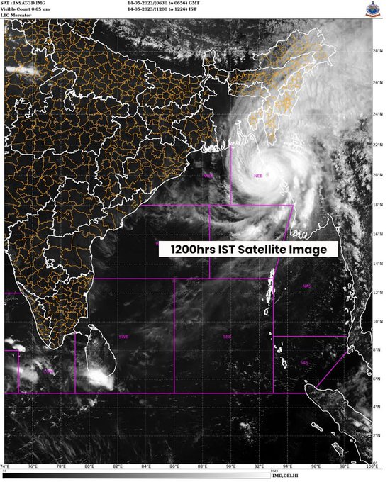
According to the latest update, landfall process of extremely severe cyclonic storm has commenced over north-west Myanmar coast. “The system over Northeast and adjoining East central Bay of Bengal moved nearly north-northeastwards with a speed of 28 kmph during past 6 hours and lay centered at 11.30 am over Northeast Bay of Bengal, about 40 km southwest of Sittwe (Myanmar) and 170 km south-southeast of Cox’s Bazar (Bangladesh). It is very likely to move north-northeastwards and cross southeast Bangladesh and north Myanmar coasts between Cox’s Bazar (Bangladesh) and Kyaukpyu (Myanmar), close to Sittwe (Myanmar) within a few hours as an Extremely Severe Cyclonic Storm with maximum sustained wind speed of 180-190 kmph gusting to 210 kmph,” it said.
Heavy rainfall along with gale wind is occurring over the north Myanmar-Bangladesh coasts and forward sector of the eye wall is entering into these coastal areas, it added.
The MeT office had earlier stated that the system is likely to cross SE Bangladesh and north Myanmar between Coxs Bazar (Bangladesh) & Kyaukpyu (Myanmar) by 2 pm.
The system has been packing winds of up to 220 kilometres per hour, which is equivalent to a category four hurricane and is expected to weaken rapidly and become a severe cyclonic storm/cyclonic storm after the landfall due to “intrusion of dry air, increased wind shear and rugged terrain”.
The Bangladeshi Meteorological Department office said the maximum sustained wind speed within around 75km (45 miles) of the centre of the cyclone was around 195 kilometres (120 miles) per hour with gusts and squalls of 215 kilometres per hour.
The tropical cyclonic storm had developed an eye on May 12 which indicates very strong winds circulating around the centre, private forecaster Skymet weather noted.
According to Dhaka Tribune, the maritime port of Cox’s Bazar has been instructed to hoist the Great Danger Signal 10 for one of the strongest cyclones in the Bay of Bengal. “Cyclone Mocha is the most powerful storm since Cyclone Sidr,” Azizur Rahman, the head of Bangladesh’s Meteorological Department, told AFP.
So far, the top three most intense cyclones in May in the Bay have been:
- Amphan, May 2020: 265 kmph
- May 1990 cyclone (Andhra Pradesh): 231 kmph
- May 1997 (Bangladesh) and Mocha: 212 kmph
Cyclone Mocha is the third-most intense cyclone to hit the Bay of Bengal in the month of May since 1982. Mocha is tied with an unnamed cyclone that hit the Bay of Bengal near Bangladesh in May 1997 at a windspeed of 212 kph. On top of the list is Cyclone Amphan which hit the Bay of Bengal in May 2020 at a windspeed of 265 kph while a cyclone that hit the coast at a windspeed of 231 kph near Andhra Pradesh in May 1990 occupies the second spot.
Some Twitter users shared impact of the cyclones along the coastal area:
This video from #Sittwe is the moment when the city was probably in the inner eyewall! #CycloneMocha #Mocha #Myanmar #IMD pic.twitter.com/DC7cy0UvxQ
— Avinas (@HidenOta) May 14, 2023
#CycloneMocha Landfall Process started and this video looks so scary.. Another few hours looks so critical.The people should face brunt of #Mocha #Cyclone pic.twitter.com/rmv1fDPcvo
— MasRainman (@MasRainman) May 14, 2023


