Bhubaneswar: There is a possibility of flood-like situation in southern and northern Odisha following heavy rainfall since the last 48 hours under the influence of cyclone Titli, which made the landfall near Palasa in Andhra Pradesh in the early morning hours of Thursday.
In Balasore, Jalaka river was flowing at a height of 5.65 metres against the danger mark of 5.5 metres at Mathani in Basta block. At Aska in Ganjam district, the Rushikulya has touched the danger mark. The water level is expected to increase further with still lashing the upper catchments of the river. Road communication between Berhampur and Sorada and Sheragada and Aska has been cut off due to overflowing of floodwaters.
In Gajapati district, Rama river was flowing at a height of about 12 feet on a bridge at Mohana. As a result, road communication from Mohana to Paralakhemundi has been disrupted. In Nabarangpur district, the Bansadhara was flowing at a height of 83.4 metres against the danger level of 83 metres.
Meanwhile, it continued to rain heavily in Rayagada district as the cyclonic storm after making the landfall had crossed over the district and moved towards the northeast.
Duty officer of Meteorological Centre, Bhubaneswar, LK Giri said the highest rainfall of 225.6 mm was recorded at Mahendragiri, followed by 223.8 mm at R. Udyagiri and 216 mm at Mohana in Gajapati district. In Ganjam district, the maximum rainfall recorded was 211.8 mm at Purushottampur while it was 173.4 mm at Rajghat in Balasore district.
The average rainfall recorded at Rushikulya and Bansadhara catchments is 133.6 mm and 86 mm respectively. Besides, the average rainfall at Budhabalanga catchments has been recorded at 73.7 mm, he added.
Talking about the rainfall, Giri said there were be extremely heavy rainfall at few places in the seven districts of Ganjam, Gajapati, Rayagada, Kandhamal, Kalahandi, Boudh and Nayagarh and heavy to very heavy rainfall in the 12 districts of Gajapati, Ganjam, Puri, Rayagada, Koraput, Kandhamal, Kalahandi, Boudh, Balangir, Jagatsinghpur, Kendrapara, Khurda, Nayagarh, Cuttack, Jajpur, Dhenkanal, Angul, Bhadrak and Balasore from Thursday night till 8.30 am the following morning.
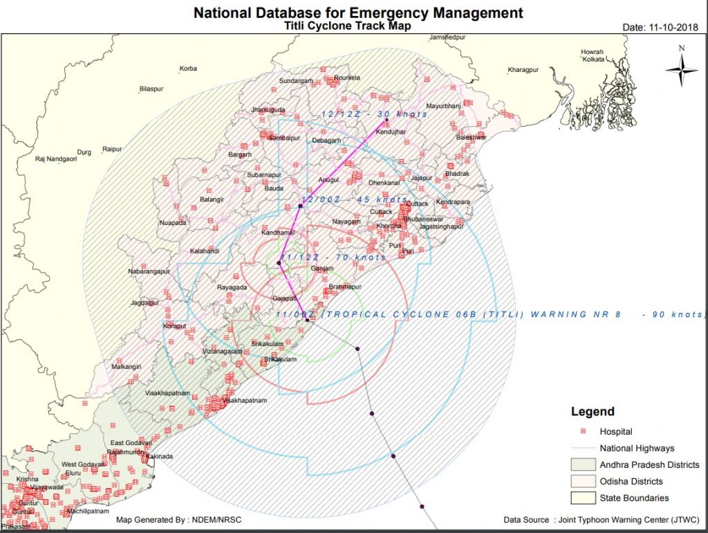
According to the latest release by the India Meteorological Department (IMD), the cyclonic storm over the north coastal Andhra Pradesh and adjoining south Odisha had moved westnorth-west with a speed of about 13 kmph and lay centred over south Odisha, about 90 km west-south-west of Gopalpur and 60 km south-south-east of Phulbani.
It will move in the north-west direction for the next 12 hours and then re-curve northeastwards towards Gangetic West Bengal across Odisha and weaken gradually to a deep depression by Thursday midnight.
The gale wind speed reaching 90-100 kmph gusting up to 115 kmph will prevail over Gajapati, Ganjam, Nayagarh, Kandhamal and Rayagada districts. However, it will gradually decrease to 50-60 kmph gusting up to 70 kmph by the evening.
On the other hand, the wind speed reaching 60-70 kmph gusting up to 80 kmph will prevail along and off the south coastal Odisha and subsequently come down to 40-50 kmph gusting up to 60 kmph by Friday morning.
The wind speed of 40-50 kmph gusting up to 60 kmph will blow along and off the north Odisha coast during next the 24 hours while in the adjoining districts of north interior Odisha, the wind speed will be 30-40 kmph gusting up to 50 kmph from Thursday afternoon till 5.30 am on Friday.
Since the intensity of the cyclonic storm has substantially decreased, the IMD has advised state government to hoist the Danger Signal No- 7 at Gopalpur and Puri ports and Local Cautionary (LC) signal No-III at Paradip and Chandbali ports.
Since the sea condition will be rough to very rough along and off north Odisha coasts on October 11 and 12, the fishermen have been advised not to venture into sea along and off the Odisha coast and north and adjoining central Bay of Bengal till October 12, the release added.
Meanwhile, the Meteorological Centre, Bhubaneswar, in a release at 8.30 pm on Thursdayissued severe thunderstorm warning accompanied by lightning, intense rainfall and strong surface wind for Jajpur, Dhenkanal, Jagatsinghpur, Cuttack, Khurda, Puri, Gajapati, Ganjam, Rayagada, Nayagarh, Kandhamal, Sambalpur, Deogarh, Sundargarh, Boudh, Sonepur, Keonjhar and Angul districts and advised people to remain indoors between 9 pm and 12 am.


