Bhubaneswar: The fresh low-pressure area over the Bay of Bengal concentrated into a depression on Friday morning and is to intensify into a deep depression in the next six hours, the India Meteorological Department (IMD)’s regional centre said.
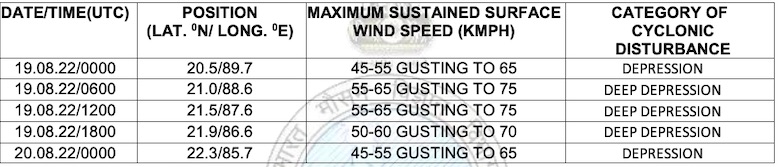
“Yesterday’s low-pressure area over northeast and adjoining areas of eastcentral Bay of Bengal, Bangladesh and Myanmar coasts moved northwestwards and concentrated into a depression. It lay centred at 5:30 am today over northwest and adjoining northeast Bay of Bengal, about 310 km east-southeast of Balasore, 250 km east-southeast of Digha and 210 km east-southeast of Sagar Islands,” the Met office said in a special bulletin issued at 9.30 am on Thursday.
ସକ୍ରିୟ ଅବପାତ pic.twitter.com/IHrsR6LXl5
— Meteorological Centre, Bhubaneswar (@mcbbsr) August 19, 2022
The system is likely to move west-northwestwards and intensify into a deep depression during the next six hours and cross West Bengal and Odisha coasts between Balasore and Sagar Islands by Friday evening. “After landfall, it would continue to move west-northwestwards across north Odisha, West Bengal and Jharkhand towards north Chhattisgarh and weaken gradually,” it said.
Squally winds reaching 45-55 kmph gusting to 65 kmph is also likely over north Bay of Bengal and along and off West Bengal, Odisha and Bangladesh coasts during next six hours. It is likely to increase becoming 55-65 kmph gusting to 75 kmph from noon till midnight over the same region. It would improve gradually becoming squally wind speed reaching 40-50 kmph gusting to 65 kmph over northwest Bay of Bengal along and off West Bengal and Odisha coasts from August 20 morning for subsequent 24 hours, the IMD added.
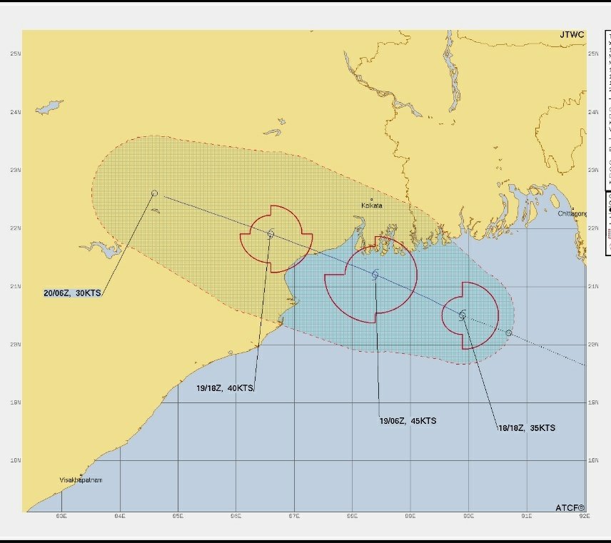
The US’ Joint Typhoon Warning Center (JTWC) has warned that the system has the potential to intensify into a cyclone.
“Numerical model guidance indicates that the system will track west-northwestward towards Kolkata and make landfall within the next 36-48 hours. It is expected to peak in intensity within the next 24-36 hours just before making landfall. The system is expected to track into an area of lower vertical wind shear allowing the system to further intensify. Maximum sustained surface winds are estimated at 28 to 33 knots. The potential for the development of a significant tropical cyclone within the next 24 hours is high,” the JTWC said.
Under the influence of the system, heavy to very heavy rain is likely to lash several districts of Odisha. The IMD has also issued a red warning for four districts.
Check the forecast for August 19-20
Aug 20 (till 8.30 am)
Red warning: Heavy to very heavy rainfall (7 to 20 cm) at a few places with isolated extremely heavy falls (>20cm) is very likely to occur over Keonjhar, Bhadrak, Balasore and Mayurbhanj districts.
Orange warning: Heavy to very heavy rainfall (7 to 20 cm) is very likely to occur at a few places over Kendrapada, Jagatsinghpur, Cuttack, Dhenkanal, Angul, Deogarh, Sundargarh, Sambalpur, Sonepur, Boudh, Bolangir and Jajpur districts.
Yellow warning: Heavy rainfall (7 to 11 cm) is very likely to occur at isolated places over Jharsuguda, Bargarh, Kalahandi, Kandhamal, Ganjam, Nayagarh, Khurda and Puri districts.
Aug 20 (8.30 am) to Aug 21 (8.30 am)
Orange warning: Heavy to very heavy rainfall (7 to 20 cm) is very likely to occur at one or two places over Jharsuguda, Sundargarh, Keonjhar, Deogarh, Sambalpur, Bargarh, Sonepur and Balangir districts.
Yellow warning: Heavy rainfall (7 to 11 cm) is very likely to occur at isolated places over Mayurbhanj, Angul, Boudh, Kalahandi, Nuapada, Nabarangpur and Dhenkanal districts.


 \r\n\r\nThe US’ Joint Typhoon Warning Center (JTWC) has warned that the system has the potential to intensify into a cyclone.\r\n“Numerical model guidance indicates that the system will track west-northwestward towards Kolkata and make landfall within the next 36-48 hours. It is expected to peak in intensity within the next 24-36 hours just before making landfall. The system is expected to track into an area of lower vertical wind shear allowing the system to further intensify. Maximum sustained surface winds are estimated at 28 to 33 knots. The potential for the development of a significant tropical cyclone within the next 24 hours is high,” the JTWC said.\r\n\r\n[caption id=\"attachment_355783\" align=\"alignnone\" width=\"856\"]
 JTWC Track of Deep Depression In Bay Of Bengal[/caption]\r\n\r\n \r\n\r\nUnder the influence of the system, heavy to very heavy rain is likely to lash several districts of Odisha. The IMD has also issued a red warning for four districts.\r\n\r\n