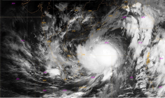
Know Why Cyclone Asani Recurved Multiple Times Near Coast

Bhubaneswar: Severe Cyclonic Storm Asani, which eventually weakened into a well-marked low-pressure area on May 12, recurved several times while changing its path from a northwest direction to a northeast track near the Andhra Pradesh coast.
According to the India Meteorological Department (IMD), most models had suggested a change in its direction from northwest to northeast near the coast. However, on May 11, when it had weakened into a deep depression, Asani moved slowly northward/northwestwards till evening and then slowly turned west-southwestwards thereafter.
The IMD said that the cyclonic storm was supposed to move northeastwards near the coast under the influence of a short amplitude westerly trough in middle and upper tropospheric levels approaching from the west. However, as the storm weakened while approaching towards the coast, the height of the storm decreased, being limited to middle tropospheric levels.
As a result, the wind steering the storm changed, being dominated by southeasterly winds, and led to a northwestward movement. However, the northwestward movement was restricted/ blocked due to an anticyclone lying over peninsular India. Thus, the system moved slowly and remained practically stationary near the coast followed by slow west-southwestward movement till it weakened into a well-marked, low-pressure area on May 12 over the region, the IMD said.
Asani also saw rapid intensification at three stages in a day on May 7 – first into a well-marked low-pressure system, a depression and into a deep depression by night, indicating the extent of warming of the Bay of Bengal this time of the year. “Ocean heat potential is a major contributor towards the growth of storms. The entire Bay of Bengal is hotter than normal and the sea surface temperature is in excess of 30°C,” the Skymet weather agency had said.
According to the IMD, Severe Cyclonic Storm Asani weakened into a deep depression before touching the coast mainly due to the following reasons:
* It entered a region with lower sea surface temperature and lower ocean heat content
* It moved very slowly (5-6 kmph against normal speed of 13 kmph) near the coast and remained within 50 km from the coastline from morning to evening of May 11. The slow movement led to upwelling of sea water and rainfall over the sea leading to further cooling of sea surface.
* Due to slow movement, there was also land interaction for longer time leading to weakening due to increased friction with land surface.
* There was cold and dry air incursion from Indian landmass in the middle and upper troposphere which are unfavourable for maintaining the intensity of any cyclonic storm.

Comments are closed.