Bhubaneswar: While Odisha is likely to experience weeklong dry weather conditions with shallow to moderate fog for the next two days, the India Meteorological Department (IMD) on Wednesday predicted formation of a low-pressure area over southeast Bay of Bengal around January 27.
“A cyclonic circulation lies over the east Equatorial Indian Ocean and adjoining southeast Bay of Bengal in lower tropospheric levels. Under its influence, a low-pressure area is likely to form over the southeast Bay of Bengal and adjoining east Equatorial Indian Ocean around January 27,” according to the forecast bulletin.
The system is likely to move west north-westwards slowly during the subsequent 3 days, it added.
FOG FORECAST FOR ODISHA
>> Shallow to moderate fog is likely at one or two places in Balasore, Bhadrak, Jajpur, Kendrapada, Cuttack, Jagatsinghpur and Khurda, Puri, Keonjhar and Mayurbhanj till 8.30 am on Thursday
>> In the subsequent 24 hours, shallow to moderate fog may occur at one or two places in Kalahandi, Kandhamal, Bolangir, Nayagarh, Ganjam, Khurda, Cuttack, Angul, Dhenkanal, Sundargarh, Keonjhar, Jajpur, Deogarh, Sambalpur.
However, there will be no large change in the night temperature during the next five days, the MeT office said.
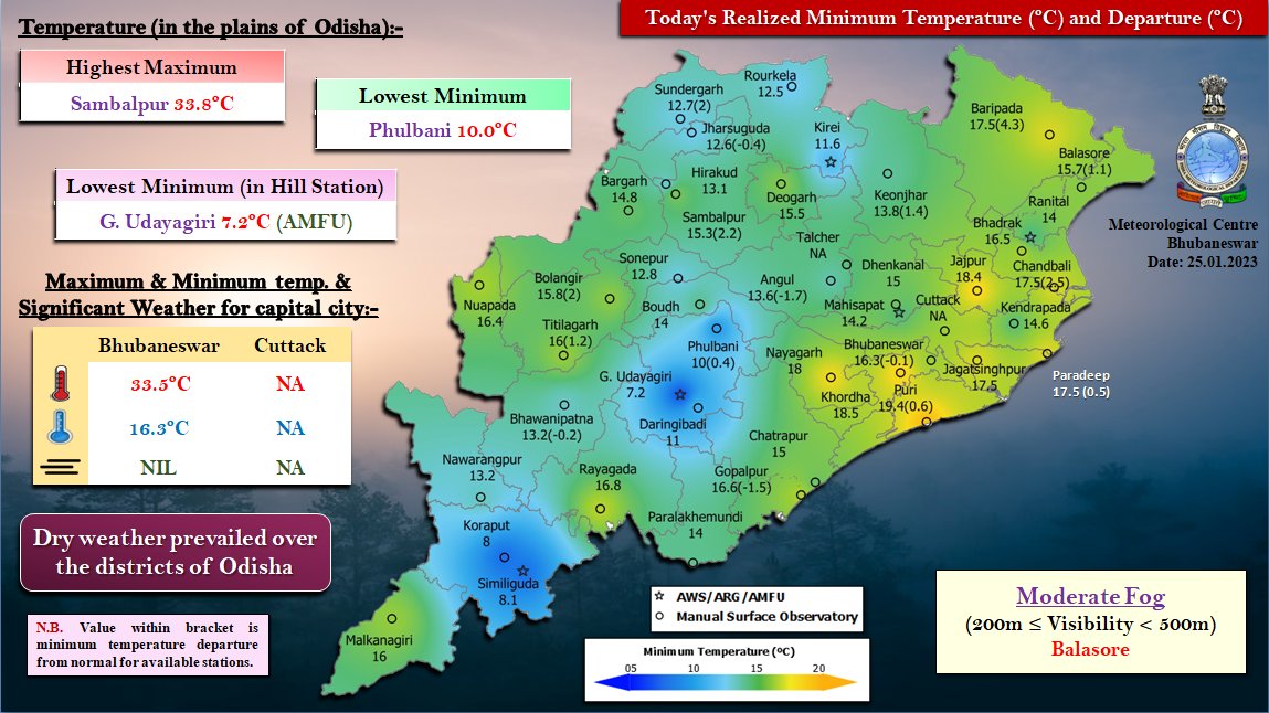
The last 24 hours saw G Udayagiri in Kandhamal recording the lowest minimum temperature of 7.2 degree Celsius followed1 by Koraput at 8 degree Celsius and Phulbani and Daringbadi in Kandhamal district at 10 degree Celsius and 11 degree Celsius respectively. Rourkela recorded 12.5 degree Celsius and Bhubaneswar 16.3 degree Celsius.


