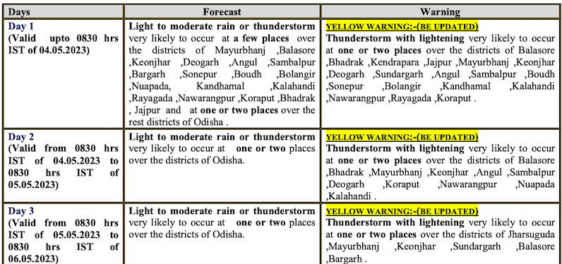
Bhubaneswar: Amid the forecast about a possible cyclone over Bay of Bengal around May 9, the India Meteorological Department (IMD) on Wednesday said that Odisha will continue to witness thunderstorm activity till May 5.
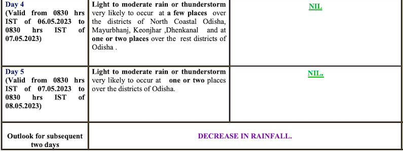
Yellow warning for thunderstorm with lightning has been issued for several districts till 8.30 am on May 6. The state will continue to experience light to moderate rain till the morning of May 7, following which there will be decrease in the intensity of rainfall, the MeT office said.
“Now, the temperature is 3/4 degree below normal. There will be a gradual rise in the mercury level by 3 to 5 degree Celsius after 3 days,” said IMD scientist Umashankar Das.
Also Read: Know What IMD DG Has To Say About Impact Of Cyclone Mocha On Odisha
A cyclonic circulation is also likely to form over Southeast Bay of Bengal around May 6. The system may turn into a low pressure area in next 48 hours on May 8. Thereafter, there is a good possibility of its intensification while moving nearly northwards towards central Bay of Bengal, he added.
Also Read: Cyclone ‘Mocha’ May Form Over Bay Around May 9-10; Check IMD & Other Forecast Models
CHECK FORECAST FOR NEXT 5 DAYS


