Wet Spell To Continue In Odisha: IMD Issues Heavy Rain Alert For Several Dists Till July 24

Bhubaneswar: With a low pressure area forming over northwest Bay of Bengal off Odisha coast, the India Meteorological Department on Thursday forecast intense spells of rain across the state during next five days.
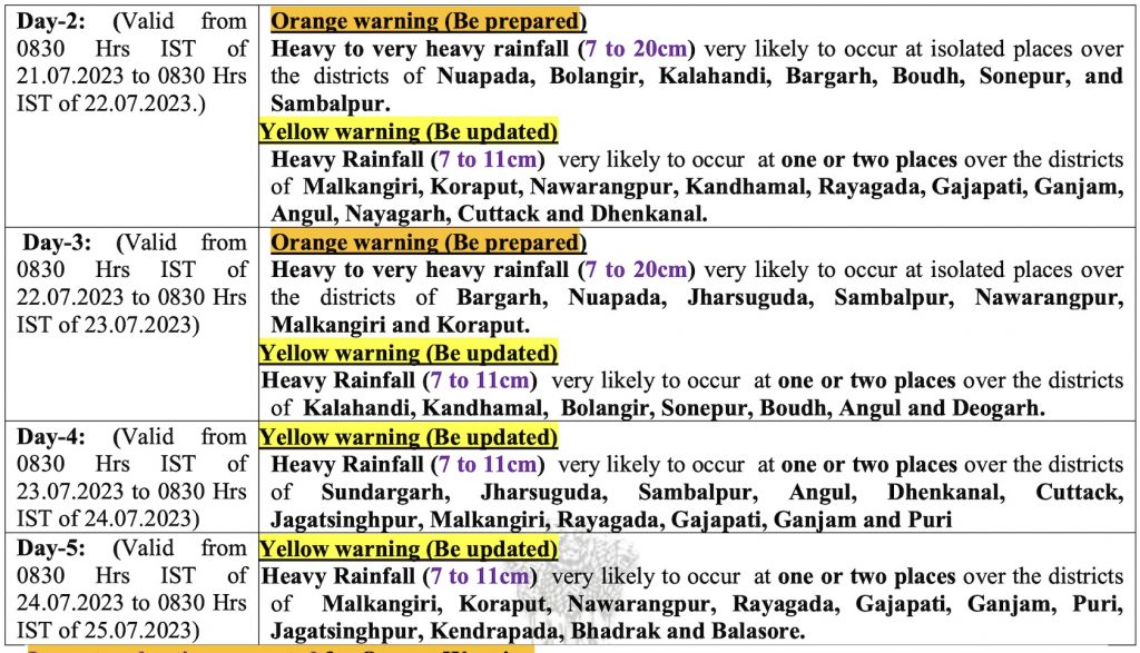
According to the midday bulletin, heavy to very heavy rainfall (7 to 20cm) is likely at isolated places in Malkangiri, Koraput, Nabarangpur, Kalahandi, Kandhamal Ganjam, Nayagarh and Balangir till 8.30 am on Friday. Yellow warning for heavy rainfall (7 to 11cm) has also been issued for one or two places in Rayagada, Gajapati, Khurdha, Sonepur, Boudh, Jagatsinghpur, Cuttack, Dhenkanal, Angul, Sambalpur and Bargarh districts.
While orange warning for heavy to very heavy rainfall continues for two more days, the wet spell with heavy rain may persist till July 24, it said.
The IMD has warned of temporary waterlogging in low-lying areas, poor visibility during intense spells of rain and traffic congestion in urban areas, possibility of wall collapse of vulnerable kutcha houses and some damage to kutcha road. There is also a possibility of landslides in vulnerable hilly areas of Malkangiri, Koraput, Nabarangpur, Kalahandi, Kandhamal, Ganjam and Gajapati and inundation of low-lying roads in some blocks of Malkangiri and Koraput districts due to continuation of heavy rain activity.
Squally weather with gusty surface wind speed reaching 40 to 50 kmph is very likely along & off Odisha coast, northwest adjoining West central Bay of Bengal till July 21 due to the low pressure and strong monsoon flow. Fishermen are advised not to venture into sea along & off Odisha coast, Northwest & adjoining West Central Bay of Bengal during this period, it added.
Comments are closed.