Bhubaneswar: The possible Cyclone Mocha over Bay of Bengal is raising the heat in Odisha. The day temperature is likely to be 40 degree Celsius or more at a few places during the next 3-4 days, the India Metrological Department (IMD) said on Tuesday.
A Depression is likely to form over Southeast Bay of Bengal and adjoining South Andaman Sea by this evening and turn into a cyclonic storm over Southeast Bay of Bengal and adjoining areas of East Central Bay of Bengal & Andaman Sea around May 10. The cyclone will possibly intensify into a Very Severe Cyclonic Storm (VSCS) by May 12 with wind speed of 130 kmph while moving north-northwestwards after which it will change course and turn north-northeast towards Bangladesh-Myanmar coasts.
Also Read: Consensus Among Weather Models On Possible Movement & Landfall Of Cyclone Mocha; Check Here
Meanwhile in Odisha, hot and discomfort weather will prevail at a few places for 3-4 days. People have been advised to take precautionary measures while going outside.
Notably, the mercury touched 40 degree Celsius and more at three places in the state by 2.30 pm. Jharsuguda recorded the highest 42.2 degree Celsius followed by Sambalpur (41.2) and Hirakud (40). Bhubaneswar recorded 38.2 degree Celsius. The Odisha capital had recorded 32.6 degree Celsius at 8.30 am.
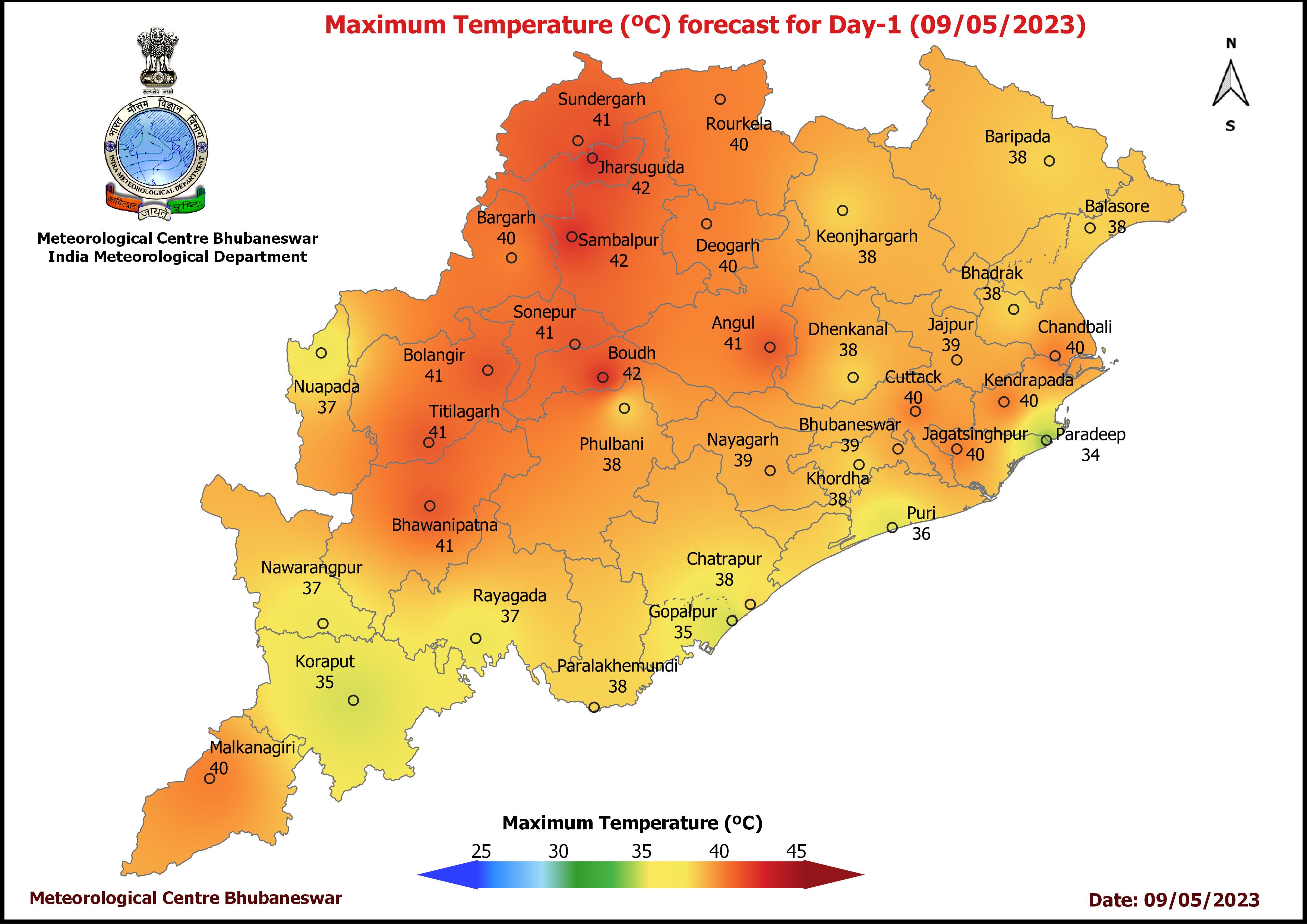
On Monday, 14 places recorded day temperature of 40 degrees Celsius or more with Boudh being the hottest place with maximum temperature of 42 degree Celsius followed by Jharsuguda and Sambalpur at 41.6 degree each.
The MeT office has also issued yellow warning for thunderstorm with lightning at one or two places in Malkangiri, Koraput, Keonjhar and Mayurbhanj till 8.30 am on Wednesday. Light to moderate rain is likely at a one or two places in Malkangiri, Koraput, Rayagada, Nabarangpur, Kalahandi , Kandhamal, Ganjam, Gajapati, Nayagarh, Khurda, Keonjhar, Mayurbhanj and Balasore during this period. Dry weather may prevail in the remaining parts of the state.
While there is no more warnings for the state, it will continue to rain at some places in coastal and southern parts till May 13. “The possibility of a few districts in the state receiving rainfall under the influence of the system cannot be ruled out,” said a weather expert.
Also Read: Low Pressure Over Bay Becomes Well Marked, Cyclone Mocha To Form Tomorrow: IMD
According to IMD, east and northeast, and adjoining central India are likely to experience fairly widespread to widespread rainfall with isolated heavy falls mainly from May 11-17 under influence of the likely formation of cyclogenesis over the Bay of Bengal and its movement.
Though the agency is yet to make prediction on the intensity and landfall of the cyclonic storm, the system is expected to eventually make landfall between Bangladesh and Myanmar around May 14. The ECMWF model’s track forecast has shifted more easterly, which means the cyclone’s impact on Odisha may now be less severe than previously predicted.
However, Odisha, Andaman, and West Bengal have been put on high alert.
“During the course of recurvature, coastline of North Odisha and West Bengal will fall within strike range, albeit mild, to witness cloudy sky, possibly strong winds and may be rains as well. Sea condition will be terribly rough for boats, trawlers and fishing vessels. The storm will head northeastward towards Bangladesh later in the day on May 12,” private forecaster Skymet said.
Borderline areas of South Bangladesh and extreme northern parts of Myanmar will have to brace for the direct hit of Mocha. Actually, the point of impact on the coastline depends on the timing and area for commencement of recurvature, it added.
Sea conditions over Southeast and adjoining Central Bay of Bengal and Andaman Sea will remain rough to very rough on May 9, becoming high to very high on May 10-11 over Central and Southeast Bay of Bengal and very high to phenomenal during May 12-13 over eastcentral Bay of Bengal.
Gale wind speed may become 130-140 kmph gusting to 150 kmph over eastcentral Bay of Bengal on May 12-13.
Fishermen, small ships, boats and trawlers have been advised not to venture into Southeast and Central Bay of Bengal and Andaman Sea from May 9 onwards.


