Bhubaneswar: The southwest monsoon is likely to set over Odisha, which saw pre-monsoon showers in southern districts on Tuesday, in 2-3 days, the India Meteorological Department (IMD) informed on Wednesday.
“Conditions are favourable for further advance of Southwest Monsoon over some more parts of south Peninsular India, some parts of Odisha, some more parts of Gangetic West Bengal, Jharkhand, Bihar and some parts of East Uttar Pradesh during next 2-3 days.”
The Met Office further said that isolated heavy rainfall is likely in Odisha between June 21 and June 25 with isolated very heavy falls on June 23-24. Heatwave to severe heatwave conditions, however, are likely to continue in isolated pockets in interior Odisha on June 21-22.
Senior meteorologist Jason Nicholls tweeted that monsoon, which was stalled over the past couple of days, is expected to advance into more parts of Andhra Pradesh, South Maharashtra, parts of Odisha and parts of East Uttar Pradesh during the next few days.
Meanwhile, the IMD Bhubaneswar has issued heavy rainfall alerts for one or two places in Kalahandi, Kandhamal, Nabarangpur, Koraput, Keonjhar and Mayurbhanj districts till 8.30 am on Thursday. Thunderstorm with lightning very likely to occur in Kandhamal, Kalahandi, Balangir, Boudh, Ganjam, Sonepur, Angul, Dhenkanal, Keonjhar, Cuttack, Nayagarh, Mayurbhanj, Balasore, Bhadrak, Jajpur.
It has also forecast heatwave for some places in Sambalpur, Jharsuguda, Sundargarh and Bargarh districts during this period.
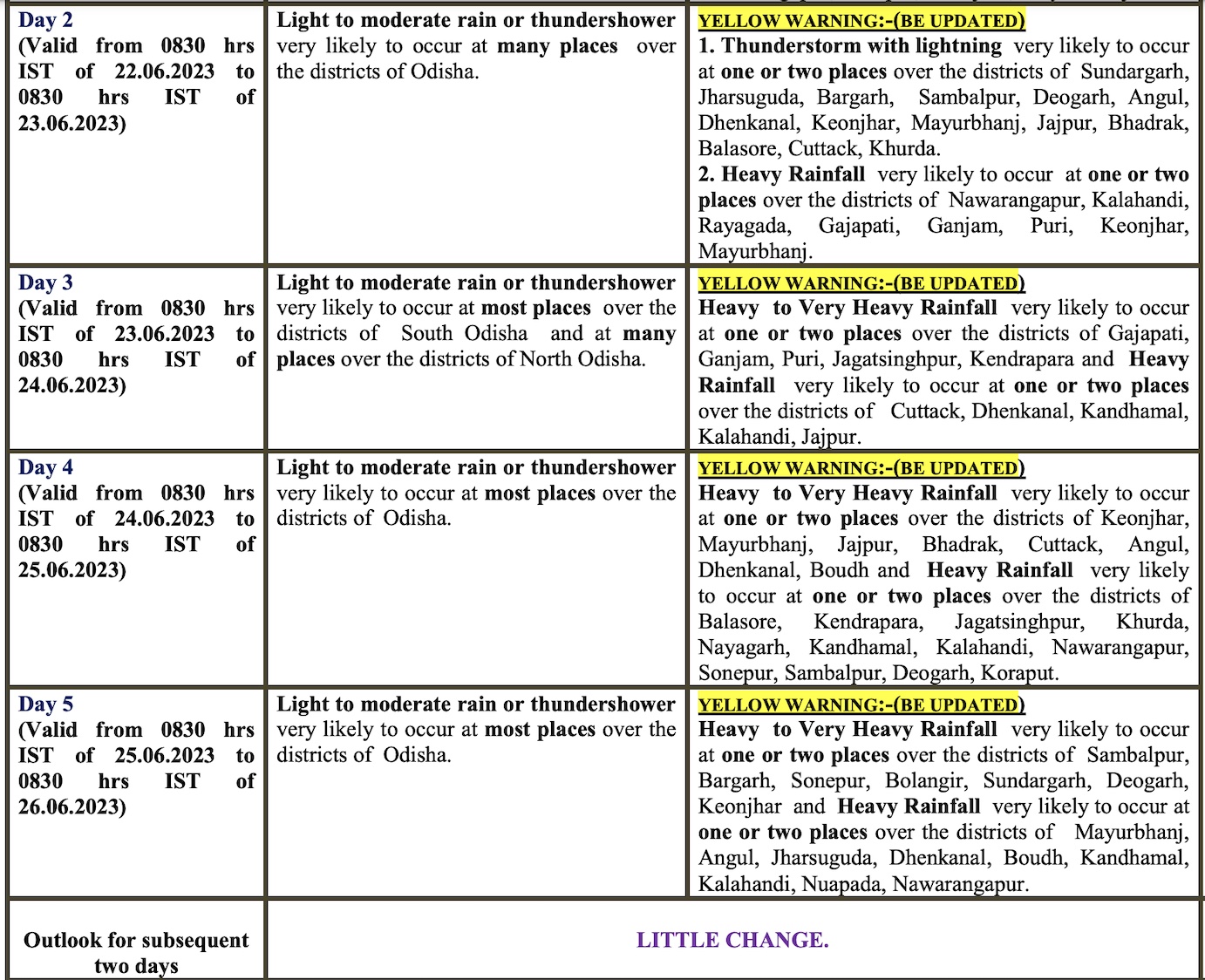
While there is no further heatwave warning for the state, the intensity of rainfall is likely to increase further from June 23. Check the forecast for next 4 days here:
The IMD further said that the day temperature us very likely to fall further by 3 to 5 oC at many places in Odisha during next 3 days with no large change thereafter.
