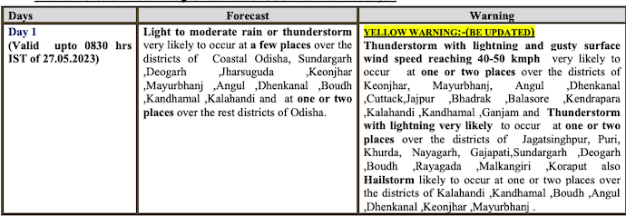
Bhubaneswar: While heatwave will continue to prevail in some pockets of Odisha for another 5 days, the India Meteorological Department (IMD) on Friday forecast thunderstorm with lightning and gusty surface wind speed reaching 40-50 kmph in several districts for 2 days.
The MeT office has issued yellow warning for thunderstorm with lightning , gusty surface wind speed reaching 40-50 kmph and light to moderate rain in some parts of Keonjhar, Mayurbhanj, Dhenkanal, Khurda (including Bhubaneswar), Cuttack (including Cuttack city), Nayagarh, Kalahandi, Rayagada and Ganjam till 5 pm.
Besides rain and thunderstorm activity, hailstorm is also likely at one or two places in Kalahandi, Kandhamal, Boudh, Angul, Dhenkanal, Keonjhar and Mayurbhanj till Saturday morning.
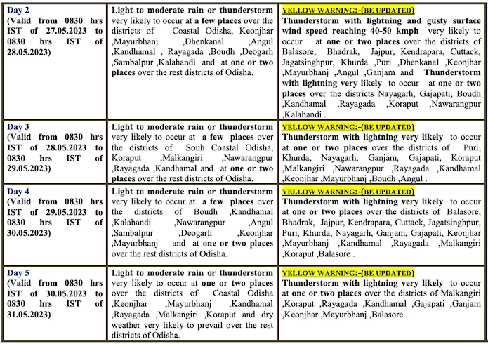
Almost all regions are likely to experience light to moderate rain till May 29.
Check the forecast here:
The MeT office further said that there will be no large change in the day temperature at many places in the state and the mercury level is likely to be 42 degree Celsius or more at one or two places in Interior Odisha – Sundargarh, Sambalpur, Angul, Boudh, Sonepur, Jharsuguda, Bargarh during the next 5 days.
Notably, rain and lighting activity accompanied by gusty wind had hit 11 coastal and central Odisha districts, bringing down day temperature sharply and providing much-needed relief from the sweltering conditions. The twin cities of Bhubaneswar and Cuttack received 14.5 mm and 15.4 mm of rainfall respectively.
Talcher had recorded the day’s highest maximum temperature of 42.8 degree C followed by 42.7 at Sambalpur, 42.4 at Nuapada and 42.2 at Jharsuguda and Sundargarh.


