Will Cyclone Asani Touch Odisha Coast? Check Latest Update From IMD

Bhubaneswar: The forecasted Cyclone ‘Asani’ is likely to change the direction of its path after May 10 evening, the India Meteorological Department (IMD) said on Saturday.
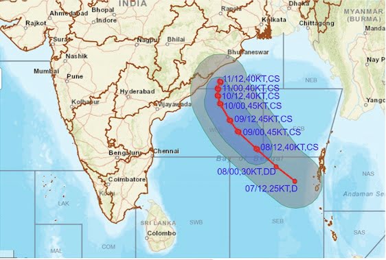
In its noon bulletin, the MeT office said that the well-marked low-pressure area over Southeast Bay of Bengal and adjoining South Andaman Sea is very likely to move northwestwards and intensify into a depression over southeast Bay of Bengal during the next 6 hours and further into a cyclonic storm over eastcentral Bay of Bengal by May 8.
“It is very likely to continue to move northwestwards till May 10 evening and reach westcentral and adjoining northwest Bay of Bengal off north Andhra Pradesh and Odisha coasts. Thereafter, it is very likely to recurve north-northeastwards and move towards the northwest Bay of Bengal off Odisha coast,” it added.
IMD senior scientist RK Jenamani said it will move away from Odisha coast and recurve from May 10 evening. There is no possibility of touching the coast, he added.
Special Relief Commissioner (SRC) Pradeep Jena also tweeted about this development.
Latest from @Indiametdept . pic.twitter.com/FYLqLYDvck
— Pradeep Jena IAS (@PradeepJenaIAS) May 7, 2022
Director of Centre for Environment and Climate (CEC) of SOA University Sarat Sahu had earlier told the media that the tropical storm may change its course on May 10. “The cyclone may change its path to north or north-eastwards and move along the Odisha coast or cross Jagatsinghpur and Kendrapada districts. There is also a possibility that the storm will move towards West Bengal or Bangladesh coasts,” he said.
He further said if the cyclone changes its path, its intensity will weaken. “The sea surface temperature near the coast is not very warm. Besides, the land is also not warm due to the recent thundershower activity. So, once the system crosses the land, its intensity will reduce,” he said.
Also Read: Odisha’s Tryst With 10 Cyclones In Over 2 Decades; Many Hits & A Few Misses
Private weather forecaster Skymet had also hinted at the possibility of the storm re-curving to run parallel to the coastline of Andhra Pradesh and Odisha and head for West Bengal and Bangladesh.
“The statistical records of climatology leave a bi-fold trajectory for the cyclone. The first scenario takes the storm for a direct strike over bordering areas of north coastal Andhra Pradesh and south Odisha. The alternate trajectory, albeit equally strong, can make the storm re-curve to run parallel to the coastline of Andhra Pradesh and Odisha and head for West Bengal and Bangladesh,” it said.
Also Read: After IMD, JTWC Issues Cyclone Alert In Bay; Storm To Strike South Odisha Coast Or…

Comments are closed.