Cyclone Fani Likely To Cross Odisha Coast On May 3: IMD

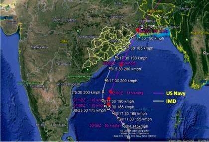
Bhubaneswar: The very severe cyclonic storm ‘Fani’ is very likely to recurve north-northeast and cross Odisha coast between Gopalpur and Chandbali, to the south of Puri, around afternoon on May 3, the India Meteorological Department’s (IMD’s) afternoon bulletin said on Tuesday.
According to the release, the cyclonic storm over the southeast and adjoining southwest Bay of Bengal has moved northwest with a speed of about 22 kmph in the last six hours and lay centred over the southwest Bay and adjoining southeast of Bengal about 800km south of Puri, 620km south-southeast of Vishakhapatnam and 660km north-northeast of Trincomalee (Sri Lanka).
It is very likely to intensify further into an extremely severe cyclonic storm in the next 12 hours and move northwest till May 1 evening and thereafter recurve north-northeast and cross Odisha coast between Gopalpur and Chandbali, to the south of Puri, around afternoon on May 3 with maximum sustained wind speed of 175-185kmph gusting up to 205kmph.
Under its influence, there will be light to moderate rainfall at many places with heavy to very heavy rainfall at isolated places over south coastal Odisha on May 2. The rainfall is likely to increase with rainfall at most places and heavy to very heavy rainfall at a few places with extremely heavy rainfall (more than 20 cm) at isolated places over coastal Odisha and its adjoining districts of interior Odisha on May 3 and over north Odisha on May 4.
During the period, squally wind speed reaching 40-50 kmph with gusting up to 60 kmph is very likely to occur along and off the north Andhra Pradesh and Odisha coasts from May 2. The wind speed will increase further to 60-70 kmph with gusting up to 85 kmph from the morning on May 3 and become 175-185 kmph with gusting up to 205 kmph over Odisha coast at the time of the landfall.
The condition of the sea is likely to be very rough to high along and off the north Andhra Pradesh coasts between May 1 and 3 and high to phenomenal along and off the Odisha and Bengal coasts between May 2 and 4.
Fishermen are advised not to venture into deep sea areas in the northwest and the adjoining west-central Bay of Bengal along and off Odisha and Bengal coasts from May 2 to 4. Those who are out in deep sea areas are advised to return to the coasts by evening on May 1, the bulletin said.
Since the surge of the cyclonic storm is most likely go up to a height of about 1.5m, the high tide is very likely to inundate low-lying areas in Ganjam, Khurda, Puri and Jagatsinghpur districts at the time of landfall. Keeping this in view, IMD has advised the state government to suspend fishing operations and carry our extensive evacuation of people from the low-lying areas. Apart from this, it has advised diversion or suspension of rail and road traffic and asked people in vulnerable areas to remain indoors.
The bulletin further said that the cyclonic storm was most likely to cause extensive damage to all types of kutcha houses, some damage to old, badly-managed pucca structures, uproot communication and power poles, disrupt rail/road link at several places and cause extensive damage to standing crop, plantations and orchards in Ganjam, Gajapati, Khurda, Puri and Jagatsinghpur districts.

Comments are closed.